1914 Map of Bangalore: The British Era Cantonment Town
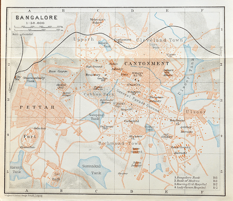
A rare 1914 vintage map of the British-era Cantonment Town of Bangalore (Bengaluru). Following the 4th Anglo-Mysore War of 1799, the cantonment was established in 1809 in Bangalore. Designed primarily to accommodate British troops and associated civilian communities. The map offers a remarkable glimpse into a city shaped by British military influence. Expanding railway connections and the growth of commercial and residential neighbourhoods.
The city had undergone a remarkable transformation since the British occupation of its fort and Pettah in 1791. Bangalore had developed into two distinct urban centres. The historic Pettah, with its traditional markets and crowded streets, and the British Cantonment (now Shivaji Nagar), which developed into a major military and administrative settlement.
The 1914 map reveals this contrast through its network of roads, residential quarters, commercial districts and military establishments. Prominent landmarks include Bangalore Fort and Pettah. Also the railway stations, the Cantonment parade ground, the racecourse, and the extensive grounds of Cubbon Park. Together, these features offer a vivid picture of Bangalore’s expanding urban landscape under British rule.
One of the most intriguing features of this 1914 map is the abundance of lakes and tanks scattered across the city. Reflecting the city’s historic dependence on carefully developed water bodies. Sampangi Tank, Sulakunte Tank, and other water bodies appear as prominent features of the landscape, alongside open spaces and areas of cultivation. Many of these historic lakes have since vanished, been encroached upon, or been reduced in size as Bangalore expanded.
Did you know- Cubbon Park used to be a buffer zone between the cantonment and the town, and locals had to pay a fee to cross from the town to the cantonment.