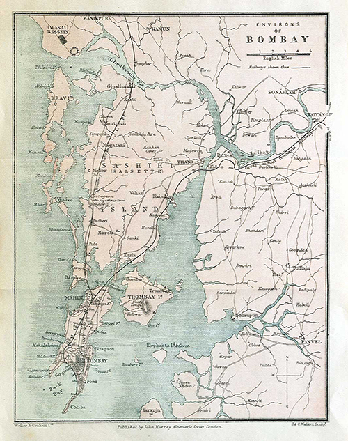
1905 Map of Bombay Islands During The Reclamation Era, Circa 1840
A 1905 map offers a glimpse of Bombay (Mumbai) as it appeared during the reclamation era around 1840. The extensive land reclamation projects would dramatically alter the shape of the city. At the time, Bombay was still defined by its original island geography. Waterways, creeks, and tidal areas separated land that would later be joined together. The map provides a significant record of Bombay’s changing landscape, when the presence of the sea was far greater than it is today.
Over the following decades, ambitious reclamation schemes transformed Bombay’s coastline. Creating new land for roads, neighbourhoods, commercial districts and eventually some of the city’s most recognisable landmarks. This 1905 map of Bombay is particularly interesting because it looks backward. Preserving the landscape of an earlier era when much of the land did not yet exist in its present form.
The Hornby Vellard, constructed between 1782 and 1784 under British Governor William Hornby, was a landmark engineering project designed to close the tidal breach between Worli and the Bombay islands. By blocking the flow of seawater through the Great Breach, it helped protect low-lying areas of Bombay from flooding. It created an important foundation for the reclamation and consolidation of the city’s islands.
Following the construction of the Vellards, causeways were built to link one island with another. Causeways were raised roads or embankments built across a low-lying area, waterway, marsh, or tidal channel, allowing people, carts, and later vehicles to travel from one side to the other. The old Bombay causeways were particularly important because the city consisted of separate islands and was surrounded by tidal waters and marshy areas. They were essentially land links between places that were previously separated by water, such as the following:
Sion Causeway (1803): Linked main Bombay island to Salsette island for carts and foot traffic.
Duncan Causeway (1803): Further connected Sion and Salsette.
Colaba Causeway (1838): Joined the southern tip of the old town to Colaba Island.
Mahim – Bandra Causeway (1845): Bridged the northern marshy gap between Mahim and Bandra.
Did you know – Vellard was derived from the Portuguese word vallado, meaning “Barrier”.