
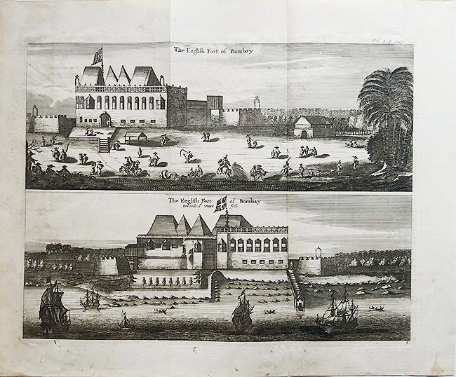
The British Fort & Castle In Bombay, Antique Plan 1755

An antique 1755 plan of the British Fort and castle in Bombay (Mumbai). Steel engraving on handmade paper, it measures 16 x 13 inch. The plan shows the view of the castle which was part of the Bombay Fort or Fort George. The British fortified the city against attacks, protecting the island town from seaborne assailants.
The Fort was built on the “H” shaped island, called Bombay, which was one of the seven islands. The governing castle at its center, which served as the Government House until the 1770s. Later Parel became the new place for the Government House. Yet again it was shifted this time to Malabar Hill in 1883. Since then becoming the Government residence now called Raj Bhavan.
The walls of Fort George’s were demolished in 1861 on the orders of the new Governor Bartle Frere. Although the place is still called Fort to this day. By the early 1800s, threats from the Mughals and Marathas diminished. There was no nuisance from the Portuguese since they had gifted the island to the English King as dowry in 1668.
See also History of a City. See post View Of Bombay Fort & Harbour – Old Print 1840
Did you know- the Fortification in Mumbai was built by the British in 1715 and not by the Portuguese as mistakenly thought.
From the collection- Raja Ravi Varma’s “Birth of Shakuntala” Oleograph of c1894., Bombing of Madras By Emden WW1 – Old Print 1914., Salsette or Mumbai Suburban – Vintage Map 1893., Chitpore Road British India Calcutta – Old Photo 1914